 An official website of the United States government.
  Official websites use .gov
A .gov website belongs to an official government organization in the United States.
Official websites use .gov
A .gov website belongs to an official government organization in the United States. Secure .gov websites use HTTPS
A lock or https:// means you’ve safely connected to the .gov website. Share sensitive information only on official, secure websites.
Secure .gov websites use HTTPS
A lock or https:// means you’ve safely connected to the .gov website. Share sensitive information only on official, secure websites.Coastal Conversations Podcast: Episode 1
The coral reefs at the foot of Florida are legendary, making up a barrier reef that spans more than 255 continuous miles making it the fifth longest in the world. It is home to an incredible array of marine life. But these reefs, like coral reefs across the globe, are in serious trouble. In recent decades in particular, the reefs within the Florida Keys National Marine Sanctuary have been damaged by hurricanes, bleaching, disease, and heavy human use. Now, NOAA and its partners have launched an initiative titled: Restoring Seven Iconic Reefs: A Mission to Recover the Coral Reefs of the Florida Keys. In this episode, NOAA scientists explain the technology and processes for assessing the health of the coral reef.
Listen here:
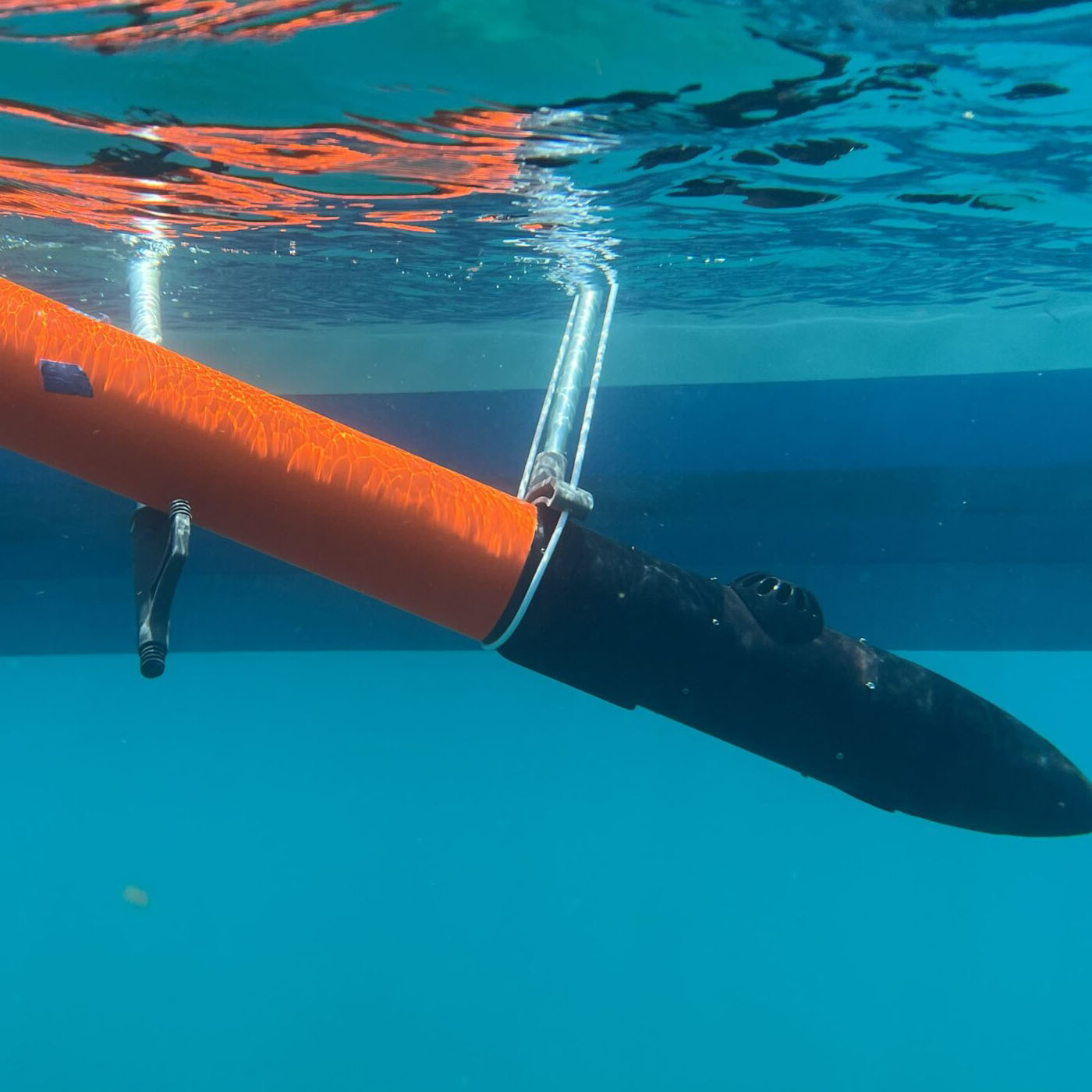
NCCOS researchers used this micro-sized uncrewed underwater vehicle (UUV) to collect imagery. These UUVs are much smaller than traditional AUVs at just four-feet long. Each of these torpedo-shaped self-propelled vehicles are mounted with a high-resolution camera and can be programmed to fly highly specific paths over the seabed.
EPISODE TRANSCRIPT
Kevin: Welcome, you’re listening to Coastal Conversations, the National Centers for Coastal Ocean Science Podcast. I’m Kevin Mcmahon. Most of you will be familiar with this sound [series of beeps and boops]. You might assume that it came from a submarine, but these data pings were actually from something that might be considered a submarine’s younger sibling. These pings are coming from an autonomous underwater vehicle, or AUV. This device feature prominently in today’s episode. Before we join today’s featured researchers, here’s a brief overview. The coral reefs at the foot of Florida are legendary, making up a barrier reef that spans more than 255 continuous miles making it the fifth longest in the world. It is home to an incredible array of marine life. But these reefs, like coral reefs across the globe, are in serious trouble. In recent decades in particular, the reefs within the Florida Keys National Marine Sanctuary have been damaged by hurricanes, bleaching, disease, and heavy human use. Recently, NOAA and its partners have launched a new initiative they are calling. This is one of the largest investments in coral reef restoration anywhere in the world. Here’s Shay Viehman from the Center’s Coastal Resilience, Restoration, and Assessment Branch, to tell us a little more:
Shay: Mission Iconic Reefs is a coral reef ecosystem restoration effort in the Florida Keys National Marine Sanctuary. It focuses on seven reefs that stretch from Eastern Dry Rocks Reef off of Key West up to Carysfort Reef in Key Largo. Iconic Reefs is led by NOAA but is a collaboration amongst the community and many partners, including federal and state, non-governmental organizations, academia, and [inaudible]. The most important aspect of Iconic Reefs is the people. This is a massive effort that is relying on the expertise of dozens of community partners working together to promote successful restoration effort. The restoration doesn’t just focus on corals and planting them, it also includes removing species like snails that eat the corals and restoring herbivorous species, such as urchins. The goal of Iconic Reefs is to restore these Keys reefs to healthy, vibrant ecosystem that is has a lot of reef fish diversity and a lot of fish species and a lot of reef complexity and healthy. All of which rely on healthy coral.
Kevin: In late April and early May 2023, researchers from the National Centers for Coastal Ocean Science, or NCOOS, headed down to the Keys to conduct reef surveys in support of this initiative. The team was comprised of Sarah Rojano and Shay Viehman from the Center’s Coastal Resilience, Restoration, and Assessment Branch, along with Chris Taylor, Erik Ebert, and Mike Bollinger from the Center’s Habitat mapping team.
They have completed their first mission using a new type of AUV known as a micro-sized uncrewed underwater vehicles or UUV. These UUVs are much smaller than traditional AUVs at just four-feet long. Each of these torpedo-shaped, self-propelled vehicles are mounted with a high-resolution camera and can be programmed to cruise highly specific paths over the seabed to collect a variety of imagery.
The team were kind enough to take time out from their work in the field on a breezy afternoon to speak with us.
Here’s Chris Taylor with a brief introduction and description of the UUV.
Chris: Yeah, it’s Chris Taylor here. We’re in the Florida Keys National Marine Sanctuary with Erik Ebert, Mike Bollinger from NCCOS’s Habitat Mapping team, and Sarah Rojano from the Mission Iconic Reefs team. We’re using an autonomous underwater vehicle, or AUV, that’s outfitted with a camera to conduct large area surveys of shallow water coral reefs in the sanctuary. We’re here for about two weeks conducting missions each day, weather permits. The vehicle flies about 30 minute missions and collects about four thousand images at a time. And Sarah will use those images in order to reconstruct a model of the coral reefs in order to track condition and recovery from restoration.
The AUVs we’re using are about four feet long, about four inches in diameter, have a single thruster on the back, and three fins. And they’re outfitted with battery power, a GPS antennae, and a motion sensor that helps them find their way under water. We program this torpedo-shaped AUV to fly about a 30-minute mission underwater. And again, it covers about a football field size, taking pictures along the way during the entire mission. All of these pictures are stored on the AUV and on recovery we bring them back to the lab and analyze them and put them together in a 3-dimensional model that’s used by the restoration experts and researchers to understand the condition and distribution of corals in the area.
Kevin: On this particular mission, the AUVs surveyed shallow coral reefs in an area of the marine sanctuary known as the Eastern Dry Rocks.
In about 30 minutes, the device was able to collect images that covered an area larger than a football field. That’s over 40 times the area that divers could cover in the same amount of time. The images collected will be used to construct 3D models and image mosaics of the reefscape to provide the sanctuary with information in areas where restoration is planned or already underway.
Since this is a new tool for the group, these first missions have several objectives. Here’s Chris to explain:
Chris: Well, this is a new device, and so this project is focused heavily on how well the AUV performs, how well it can navigate under water and how crisp, and clear the pictures are for us to be able to interpret the corals that are on the bottom. What we hope this can accomplish for us is a way for extend and expand the amount of photos that are taken in order to develop large photo mosaics or large images and models of the shallow water coral reefs to support the restoration of the coral reefs in the Florida Keys National Marine Sanctuary as part of Mission Iconic Reefs.
These AUVs are highly sophisticated instruments. It’s not a case of simply turning them on and letting them loose. It’s actually similar to the preflight routine you might find in an airline cockpit. Numerous functions and systems need to be checked and crosschecked before each and every deployment.
Mike: Alright let’s check fins and thrusters. Dorsal fin?
Sarah: Check!
Mike: Starboard?
Sarah: Check!
Mike: Port?
Sarah: Check!
Mike: Thruster?
Sarah: Check!
Mike: Alright, we’re recording in pinpoint.
Kevin: Once everything has been confirmed to be in full working order, the device is then gently deployed.
Mike: Alright everything checks out. Let’s bring it to the rail.
Team: At the rail.
Mike: Alright, we’re going to start…hold on. Let me start the camera. [pause] Alright. Camera started. I’m going to start the altimeter. Alright ready to bring to water starting mission.
Team: Ready to deploy.
Mike: Alright. Go ahead.
Team: Deploying.
[small splash and bubbles]
Mike: Let’s. Let’s. Boat’s clear. Let’s get the boat clear.
Team: Vehicle’s clear.
Team: Free to maneuver.
Kevin: Once the AUV has surveyed the aforementioned football fields worth of reef tract, it is recovered and the data evaluated.
Chris: So good retrieval team. Looked really good. Uh, Sarah, thank you for pulling that out of the water with the hook. Good job captain. Uh, conclusion of about a 30-minute dive. What kind of data are we looking at there, Mike?
Mike: Uh, yeah. We’ve got about 200 gigabytes of data. 30-minute dive. Um have about 16 volts of battery left. Um probably have about one more dive, maybe two left in the tank. So, something to consider.
Chris: Sounds good. Let’s go ahead and maybe planning the next dive and how much time we’ll have in the water.
Mike: Yeah, let me see how this one performed when we pull the vehicle data. And, uh, we’ll take a look at it.
Chris: How many pictures does that equate to, Mike?
Mike: Uh, it takes…that’s a good question. It takes 4000. Yeah, 200 gigs, 4000 photos. It takes two photos per second.
Kevin: Battery life is always a limiting factor on how many more deployments will be available for any given day while in the field. This is just one of a multiple of considerations, the researchers must account for each day. While most people would jump at the chance to work in the Florida Keys, a place many people would consider idyllic. Working in this popular sub-tropical environment brings its own special set of challenges.
Mike: As far as challenges go, the Florida Keys are pretty nice. But we do have challenges just like anybody else. Weather is an issue. Uh wind. Weather here can come out of nowhere. It’s difficult to predict. Uh, winds can pick up in the afternoon or not. Or pick up in the morning and lay down. And that impacts the sea conditions.
Chris: That’s a good point, Mike. When we go out, it might be nice in the morning, winds will pick up, and then all of the sudden we have a two-foot sea from a wind swell that blows in unexpectedly. So it makes it really difficult for mission planning and vehicle recovery.
Mike: It’s really important for mission planning because we got, uh, the vehicle’s not recoverable when it’s underwater and under way. So we have to plan at least 30 minutes ahead for these 30 minute missions.
Chris: As well as the folks that live here and use these reefs. There is some vessel traffic.
Sarah: Yeah, so we do need to be mindful of the vessels that are out, um, whether they have snorkelers or divers. Um, so we need to be aware of what proximity they are, um, to us when we are flying the vehicle.
Chris: Or even fishing boats that are transiting through our area. I think in a lot of cases we make clear communications to vessels that are in the vicinity and make sure everyone on board here is maintaining awareness of the weather and the conditions that we’re experiencing.
Mike: Yeah, we try to let other vessels know about our mission plan and where we’ll be operating and things like that.
Kevin: Along with the ever-changing wind and tide patterns, boat traffic, and fisherman, the warmer months of the year can bring an oppressive heat and humidity that makes physically demanding field work that much harder. But having said that, the team persevered and now have their first batch of data to take back to the lab and begin modeling. Here is Sarah and Mike discussing the anticipated products from their work.
Sarah: The main product that we’re trying to achieve is a larger scale model of all of the reefs that we’re surveying. Um, from that we hope to be able to track, uh, the benthic community and cover over the course of 10 years in addition to coral change and health in addition to growth and reciprocity. Um, so basically trying to determine the success of our restoration efforts over the course of the project.
Chris: So, Mike, Sarah used the word model as one of the products that’s being developed during this project. Can you explain what that model is and how it’s being produced?
Mike: Yeah, absolutely. The models we’re creating are three dimensional models of the reef structure and the seafloor. They are, like we’ve been saying, comprised of 4000 or more images that are all stitched together like a patch-work quilt. All the…the photos have about…they’re overlapping so we can see the same kind of structure in every…in each sequential picture. But we’re adding a tiny, tiny bit each time and we’re covering, we’re painting the entire reef with photographs. And all of those images get stitched together in an effort to create a 3-D model.
Chris: How big is the model? What’s the full scale of one of the models that we can construct with one of the AUV missions?
Mike: Yeah, as far as the model size goes, we’re shooting, we’re trying to paint a 150 by 40 meter plot, which is about the same size as a football field. A football field is about 120 meters by 40 meters.
Kevin: While the public at large will benefit from this work, however, certain groups in particular will find this information particularly valuable. Here’s Sarah to explain.
Sarah: Uh, there’s two types of groups that are going to benefit from this. So this project is a multiorganization effort, so it is going to help the scientists who are not only doing the out planting, but also trying to track the reef over time and the longevity of this project. But in addition, it’s also going to benefit the, um, good folks of Florida because we’re trying to enhance the resilience of the reef over time.
Kevin: While field missions of this sort require lengthy preparations and long days at sea, the work is rewarding to the team. Once again, here’s Sarah and Mike.
Sarah: I think what I enjoy most is being able to see the reefs that I’ve worked on for the past 10 months for the first time. It helps me get a better idea of what I’m actually looking at and have a little more appreciation for our field team and all the work that they do when they’re collecting this imagery for us.
Chris: Yeah, so you’ve seen the reefs virtually by looking at them on your desktop commuter. Just the data. So seeing them in real life gives you a better context for the scale and the scope of the activity and the work that we’re doing.
Sarah: It does. Absolutely.
Mike: Yeah, working with coral monitoring before coming to NCCOS, so coming back to these reefs, seeing them change over time, and continuing to work in coral monitoring is really enjoyable. Contributing to the effort of restoring corals.
Kevin: The conditions the researchers encountered during this particular foray were nearly ideal. This further enhanced the overall enjoyment by the crew. Here’s Erik and Chris
Chris: Yeah, one of the major aspects of this project is the research and development of using this autonomous underwater vehicle to collect images for us. We’re hoping that this vehicle will be able to collect images over a much larger area than divers can do on their own. But it’s taking us a lot of testing and evaluation to understand the capabilities and limitations. But one of the enjoyment factors of working in the Florida Keys is the conditions that we’re working in.
Erik: Yeah, the conditions we’re working in, usually are pretty clear water. And besides some of the weather and issues that might blow up. Usually, it’s pretty calm offshore. So as scientists, this is a really nice location for the research and development aspect so we can focus on the data we’re collecting and the data quality.
Chris: Yeah, clear conditions, clear visibility in the water allowing us to monitor the vehicle at times. It ensures we’re going to collect the best quality of images when the vehicle is behaving the way it should.
Kevin: The researchers we met today will continue to run surveys in the sanctuary until all seven areas have been covered. And the products they produce will prove invaluable to the restoration and continued enhancement of the coral reefs of the iconic Florida Keys.
If you’d like to learn more about the Mission Iconic Reef initiative, please visit www.sanctuaries.noaa.gov. To learn more about our role in this effort or about all the other great coastal ocean research being conducted by NCCOS, please visit our website at www.coastalscience.noaa.gov. Thank you for listening.
[sound of waves crashing and shorebirds calling]